As per Intent Market Research, the Geospatial Imagery Analytics Market was valued at USD 6.7 billion in 2024-e and will surpass USD 22.2 billion by 2030; growing at a CAGR of 18.8% during 2025 - 2030.
The geospatial imagery analytics market is experiencing significant growth, driven by the increasing availability of satellite imagery, advancements in artificial intelligence (AI), and the growing demand for accurate, real-time data across various industries. Geospatial imagery analytics refers to the process of collecting, processing, and analyzing geographical data obtained from satellites, drones, and other remote sensing technologies to derive actionable insights. These insights are used for decision-making in sectors such as agriculture, urban planning, environmental management, and defense. As the global economy becomes more data-driven, geospatial imagery analytics has become a critical tool for businesses and governments seeking to enhance operational efficiency and optimize resource management.
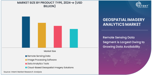
Remote Sensing Data Segment is Largest Owing to Growing Data Availability
The largest segment in the geospatial imagery analytics market is remote sensing data, which forms the foundation of geospatial analysis. The proliferation of satellite constellations and the continuous advancement in satellite imaging technologies have significantly increased the volume and variety of remote sensing data available. This segment is expanding rapidly as companies and governments alike recognize the value of this data for applications in areas such as climate change monitoring, disaster management, and urban planning. The increased availability of high-resolution data and real-time imagery has empowered organizations to make more informed decisions, fostering greater demand for remote sensing data across various industries.
The growing adoption of remote sensing data can be attributed to the advances in satellite imaging technology, which enables the collection of high-quality imagery from a wide range of Earth observation satellites. Furthermore, the integration of machine learning and AI-driven analytics has enhanced the capabilities of remote sensing data, allowing for more accurate interpretations and predictions. These advancements are expected to continue driving the growth of this segment in the coming years.
Artificial Intelligence (AI) Segment is Fastest Growing Owing to Increased Automation
In the technology segment, artificial intelligence (AI) is the fastest-growing subsegment, as it plays a key role in automating the analysis of vast amounts of geospatial data. AI algorithms, particularly machine learning and deep learning models, enable the identification of patterns, anomalies, and trends within geospatial imagery. The ability to automate data analysis and interpretation has significantly improved the speed and accuracy of decision-making, driving the widespread adoption of AI in the geospatial imagery analytics market.
AI's ability to process complex datasets, coupled with its capacity to learn from previous analyses, has made it indispensable in industries such as agriculture, urban planning, and defense. For example, AI-powered geospatial analytics tools are used for crop monitoring, infrastructure mapping, and security surveillance. The rise of AI technologies, along with the increasing need for real-time data analysis, positions AI as the most dynamic and rapidly expanding technology in the geospatial imagery analytics sector.
Agriculture & Forestry Segment is Largest Owing to High Demand for Crop Monitoring
Among the end-user industries, agriculture and forestry are the largest segments, driven by the increasing demand for precision agriculture solutions. Geospatial imagery analytics is being widely used to monitor crop health, soil conditions, irrigation patterns, and land use. This data helps farmers optimize yield, reduce waste, and make more informed decisions regarding planting and harvesting. As the global population continues to rise and the need for sustainable agriculture grows, the agricultural industry has turned to geospatial imagery analytics to address challenges such as resource management and environmental sustainability.
In particular, precision farming techniques powered by geospatial analytics enable the identification of crop stress, pest infestations, and disease outbreaks before they impact yield. This proactive approach to agriculture is not only boosting crop productivity but also reducing the environmental impact of farming practices. As a result, the agriculture and forestry sector is expected to continue driving the demand for geospatial imagery analytics technologies.
Disaster Management Segment is Fastest Growing Owing to Increasing Natural Disasters
In the application segment, disaster management is the fastest-growing area for geospatial imagery analytics. As climate change increases the frequency and severity of natural disasters such as floods, hurricanes, and wildfires, there is a heightened need for real-time monitoring and rapid response strategies. Geospatial imagery analytics plays a critical role in disaster management by providing real-time data for early warning systems, damage assessment, and resource allocation.
Advanced satellite imagery and geospatial data analytics allow for the accurate monitoring of disaster-prone areas, helping authorities and humanitarian organizations plan for and respond to emergencies more effectively. Furthermore, the use of AI and machine learning in disaster management has enhanced the precision of risk predictions and improved recovery strategies, contributing to the growing demand for geospatial imagery analytics in disaster response.
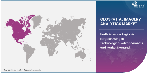
North America Region is Largest Owing to Technological Advancements and Market Demand
North America is the largest region in the geospatial imagery analytics market, owing to its advanced technological infrastructure and strong demand for geospatial data across industries such as agriculture, defense, and urban planning. The presence of major companies like Maxar Technologies, DigitalGlobe, and Esri has fueled the region's growth, providing innovative solutions for geospatial data collection and analysis. The U.S. government, particularly through agencies such as NASA and the U.S. Geological Survey (USGS), has played a key role in driving the development and adoption of geospatial technologies.
The rapid development of AI, machine learning, and remote sensing technologies in North America has further positioned the region as a leader in the geospatial imagery analytics market. With a growing focus on smart cities, environmental management, and defense applications, North America is expected to maintain its dominant position in the global market for the foreseeable future.
Competitive Landscape and Leading Companies
The geospatial imagery analytics market is highly competitive, with several major players offering innovative solutions for data collection, processing, and analysis. Leading companies such as Maxar Technologies, Esri, Airbus Defence and Space, and Planet Labs are at the forefront of this market, providing comprehensive geospatial solutions powered by advanced satellite imagery, AI, and cloud-based platforms. These companies are continuously investing in research and development to enhance their technological capabilities and expand their market presence.
Additionally, smaller players and startups are emerging with niche technologies and specialized solutions, contributing to the dynamic nature of the market. Strategic partnerships, mergers, and acquisitions are common as companies seek to strengthen their portfolios and gain a competitive edge. The increasing focus on AI, machine learning, and real-time data processing is shaping the future of the geospatial imagery analytics market, and companies that can integrate these technologies into their offerings are well-positioned for continued growth
Recent Developments:
- Maxar Technologies launched a new high-resolution satellite imagery platform that provides real-time updates for defense and intelligence sectors, improving situational awareness and decision-making.
- Planet Labs expanded its Earth observation satellite constellation to enhance its global imagery coverage, particularly focusing on environmental monitoring and disaster response.
- Esri announced an advanced GIS analytics toolset integrated with AI and machine learning capabilities, aimed at improving urban planning and resource management for government and private enterprises.
- Trimble Inc. partnered with several agricultural technology firms to integrate its geospatial imagery solutions into precision agriculture, optimizing crop yield and land use efficiency.
- Airbus Defence and Space received regulatory approval for its new hyperspectral satellite system, which will support applications in environmental monitoring and resource management across various industries
List of Leading Companies:
- Maxar Technologies
- Airbus Defence and Space
- DigitalGlobe
- Hexagon AB
- Trimble Inc.
- Esri
- Planet Labs Inc.
- Satellogic
- GeoIQ
- Fugro
- BlackSky Global
- IBM Corporation
- Microsoft Corporation
- Google LLC
- Harris Corporation
Report Scope:
|
Report Features |
Description |
|
Market Size (2024-e) |
USD 6.7 Billion |
|
Forecasted Value (2030) |
USD 22.2 Billion |
|
CAGR (2025 – 2030) |
18.8% |
|
Base Year for Estimation |
2024-e |
|
Historic Year |
2023 |
|
Forecast Period |
2025 – 2030 |
|
Report Coverage |
Market Forecast, Market Dynamics, Competitive Landscape, Recent Developments |
|
Segments Covered |
Geospatial Imagery Analytics Market by Product Type (Remote Sensing Data, Image Processing Software, Data Analytics Tools, Cloud-Based Geospatial Imagery Solutions), by Technology (Artificial Intelligence, Machine Learning, Deep Learning, Computer Vision, Geographic Information System, Remote Sensing), by End-User Industry (Agriculture & Forestry, Government & Defense, Oil & Gas, Mining & Exploration, Energy & Utilities, Environmental Management, Transportation & Logistics, Urban Planning), and by Application (Disaster Management, Environmental Monitoring, Agriculture Monitoring, Smart Cities, Land Use & Land Cover Mapping, Infrastructure Management) |
|
Regional Analysis |
North America (US, Canada, Mexico), Europe (Germany, France, UK, Italy, Spain, and Rest of Europe), Asia-Pacific (China, Japan, South Korea, Australia, India, and Rest of Asia-Pacific), Latin America (Brazil, Argentina, and Rest of Latin America), Middle East & Africa (Saudi Arabia, UAE, Rest of Middle East & Africa) |
|
Major Companies |
Maxar Technologies, Airbus Defence and Space, DigitalGlobe, Hexagon AB, Trimble Inc., Esri, Planet Labs Inc., Satellogic, GeoIQ, Fugro, BlackSky Global, IBM Corporation, Microsoft Corporation, Google LLC, Harris Corporation |
|
Customization Scope |
Customization for segments, region/country-level will be provided. Moreover, additional customization can be done based on the requirements |
|
1. Introduction |
|
1.1. Market Definition |
|
1.2. Scope of the Study |
|
1.3. Research Assumptions |
|
1.4. Study Limitations |
|
2. Research Methodology |
|
2.1. Research Approach |
|
2.1.1. Top-Down Method |
|
2.1.2. Bottom-Up Method |
|
2.1.3. Factor Impact Analysis |
|
2.2. Insights & Data Collection Process |
|
2.2.1. Secondary Research |
|
2.2.2. Primary Research |
|
2.3. Data Mining Process |
|
2.3.1. Data Analysis |
|
2.3.2. Data Validation and Revalidation |
|
2.3.3. Data Triangulation |
|
3. Executive Summary |
|
3.1. Major Markets & Segments |
|
3.2. Highest Growing Regions and Respective Countries |
|
3.3. Impact of Growth Drivers & Inhibitors |
|
3.4. Regulatory Overview by Country |
|
4. Geospatial Imagery Analytics Market, by Product Type (Market Size & Forecast: USD Million, 2023 – 2030) |
|
4.1. Remote Sensing Data |
|
4.2. Image Processing Software |
|
4.3. Data Analytics Tools |
|
4.4. Cloud-Based Geospatial Imagery Solutions |
|
5. Geospatial Imagery Analytics Market, by Technology (Market Size & Forecast: USD Million, 2023 – 2030) |
|
5.1. Artificial Intelligence (AI) |
|
5.2. Machine Learning (ML) |
|
5.3. Deep Learning (DL) |
|
5.4. Computer Vision |
|
5.5. Geographic Information System (GIS) |
|
5.6. Remote Sensing |
|
6. Geospatial Imagery Analytics Market, by End-User Industry (Market Size & Forecast: USD Million, 2023 – 2030) |
|
6.1. Agriculture & Forestry |
|
6.2. Government & Defense |
|
6.3. Oil & Gas |
|
6.4. Mining & Exploration |
|
6.5. Energy & Utilities |
|
6.6. Environmental Management |
|
6.7. Transportation & Logistics |
|
6.8. Urban Planning |
|
7. Geospatial Imagery Analytics Market, by Application (Market Size & Forecast: USD Million, 2023 – 2030) |
|
7.1. Disaster Management |
|
7.2. Environmental Monitoring |
|
7.3. Agriculture Monitoring |
|
7.4. Smart Cities |
|
7.5. Land Use & Land Cover Mapping |
|
7.6. Infrastructure Management |
|
8. Regional Analysis (Market Size & Forecast: USD Million, 2023 – 2030) |
|
8.1. Regional Overview |
|
8.2. North America |
|
8.2.1. Regional Trends & Growth Drivers |
|
8.2.2. Barriers & Challenges |
|
8.2.3. Opportunities |
|
8.2.4. Factor Impact Analysis |
|
8.2.5. Technology Trends |
|
8.2.6. North America Geospatial Imagery Analytics Market, by Product Type |
|
8.2.7. North America Geospatial Imagery Analytics Market, by Technology |
|
8.2.8. North America Geospatial Imagery Analytics Market, by End-User Industry |
|
8.2.9. North America Geospatial Imagery Analytics Market, by Application |
|
8.2.10. By Country |
|
8.2.10.1. US |
|
8.2.10.1.1. US Geospatial Imagery Analytics Market, by Product Type |
|
8.2.10.1.2. US Geospatial Imagery Analytics Market, by Technology |
|
8.2.10.1.3. US Geospatial Imagery Analytics Market, by End-User Industry |
|
8.2.10.1.4. US Geospatial Imagery Analytics Market, by Application |
|
8.2.10.2. Canada |
|
8.2.10.3. Mexico |
|
*Similar segmentation will be provided for each region and country |
|
8.3. Europe |
|
8.4. Asia-Pacific |
|
8.5. Latin America |
|
8.6. Middle East & Africa |
|
9. Competitive Landscape |
|
9.1. Overview of the Key Players |
|
9.2. Competitive Ecosystem |
|
9.2.1. Level of Fragmentation |
|
9.2.2. Market Consolidation |
|
9.2.3. Product Innovation |
|
9.3. Company Share Analysis |
|
9.4. Company Benchmarking Matrix |
|
9.4.1. Strategic Overview |
|
9.4.2. Product Innovations |
|
9.5. Start-up Ecosystem |
|
9.6. Strategic Competitive Insights/ Customer Imperatives |
|
9.7. ESG Matrix/ Sustainability Matrix |
|
9.8. Manufacturing Network |
|
9.8.1. Locations |
|
9.8.2. Supply Chain and Logistics |
|
9.8.3. Product Flexibility/Customization |
|
9.8.4. Digital Transformation and Connectivity |
|
9.8.5. Environmental and Regulatory Compliance |
|
9.9. Technology Readiness Level Matrix |
|
9.10. Technology Maturity Curve |
|
9.11. Buying Criteria |
|
10. Company Profiles |
|
10.1. Maxar Technologies |
|
10.1.1. Company Overview |
|
10.1.2. Company Financials |
|
10.1.3. Product/Service Portfolio |
|
10.1.4. Recent Developments |
|
10.1.5. IMR Analysis |
|
*Similar information will be provided for other companies |
|
10.2. Airbus Defence and Space |
|
10.3. DigitalGlobe |
|
10.4. Hexagon AB |
|
10.5. Trimble Inc. |
|
10.6. Esri |
|
10.7. Planet Labs Inc. |
|
10.8. Satellogic |
|
10.9. GeoIQ |
|
10.10. Fugro |
|
10.11. BlackSky Global |
|
10.12. IBM Corporation |
|
10.13. Microsoft Corporation |
|
10.14. Google LLC |
|
10.15. Harris Corporation |
|
11. Appendix |
A comprehensive market research approach was employed to gather and analyze data on the Geospatial Imagery Analytics Market. In the process, the analysis was also done to analyze the parent market and relevant adjacencies to measure the impact of them on the Geospatial Imagery Analytics Market. The research methodology encompassed both secondary and primary research techniques, ensuring the accuracy and credibility of the findings.
.jpg)
Secondary Research
Secondary research involved a thorough review of pertinent industry reports, journals, articles, and publications. Additionally, annual reports, press releases, and investor presentations of industry players were scrutinized to gain insights into their market positioning and strategies.
Primary Research
Primary research involved conducting in-depth interviews with industry experts, stakeholders, and market participants across the E-Waste Management ecosystem. The primary research objectives included:
- Validating findings and assumptions derived from secondary research
- Gathering qualitative and quantitative data on market trends, drivers, and challenges
- Understanding the demand-side dynamics, encompassing end-users, component manufacturers, facility providers, and service providers
- Assessing the supply-side landscape, including technological advancements and recent developments
Market Size Assessment
A combination of top-down and bottom-up approaches was utilized to analyze the overall size of the Geospatial Imagery Analytics Market. These methods were also employed to assess the size of various subsegments within the market. The market size assessment methodology encompassed the following steps:
- Identification of key industry players and relevant revenues through extensive secondary research
- Determination of the industry's supply chain and market size, in terms of value, through primary and secondary research processes
- Calculation of percentage shares, splits, and breakdowns using secondary sources and verification through primary sources
.jpg)
Data Triangulation
To ensure the accuracy and reliability of the market size, data triangulation was implemented. This involved cross-referencing data from various sources, including demand and supply side factors, market trends, and expert opinions. Additionally, top-down and bottom-up approaches were employed to validate the market size assessment.
NA